Frequently asked questions
Here I have put together a few hints and tips that may be useful to one or the other when planning and preparing a canoe trip on the Danube. However, I would like to point out that this list is as incomplete as it is subjective. It is merely intended to provide a brief overview and offer a few useful links.
However, some things, such as border control legislation, can change and I am referring here to my experiences in the years 2008-2013.
Is it possible to paddle the entire Danube?
Apart from a section of the upper Danube in Baden-Württemberg, which is also closed to paddlers and for which a special permit is required, paddling is possible on the entire river. From Kelheim onwards, the Danube is a federal waterway, large ships operate on it and the rules of the water and shipping authorities apply. But that sounds more complicated and complicated than it actually is.
It is not possible for small boats to navigate the Danube-Black Sea Canal.
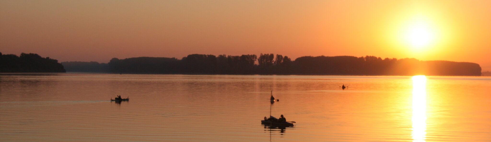
Is a trip on the Danube dangerous?
Basically not. The Danube is – especially in Germany and Austria – heavily regulated, there is no white water, but it is a large river with sometimes strong currents. Experience in paddling and on flowing waters does not hurt at first, but in my experience it is not absolutely necessary if you are careful and do not tend to overestimate yourself.
One of the most important rules is: keep your distance! This applies to boats, bridge piers, cable ferries and their moorings, buoys and basically all obstacles in the water. The danger of buoys and ropes in particular is often underestimated because they look so inconspicuous, but most accidents happen on them and paddlers die every year.
As for the seemingly ineradicable prejudice that “Eastern Europe”, that “The Balkans” are dangerous, this is nothing more than a prejudice, but it is wrong. Even if, unfortunately, many people like to repeat it again and again, tell horror stories and reproduce it over and over again. It is wrong. Incidentally, this has been confirmed time and again for years by the travel information issued by the German Foreign Office.
Which books/maps are recommended?
I consider the DKV guidebook volume 9, »Die Donau und ihre Nebenflüsse«, to be very good, indeed indispensable, travel reading. No paddler should paddle the Danube without it. There is nothing better for Germany and Austria, it is accurate down to the meter. Everything is right! It is very good for Slovakia and Hungary, but the first small, albeit rather insignificant, errors creep in.
Up to the Hungarian-Croatian-Serbian border there are hand-drawn but accurate river course sketches, and the locks are marked with small maps. The further downstream you go, the more incomplete, shorter and incorrect the information becomes. However, it remains a practical aid up to the estuary. However, the brief country information is only of limited help.
In this respect, however, the cycling maps from Bikeline »Donau-Radweg 4. Von Budapest nach Belgrad« and »Donau-Radweg 5. Von Belgrad zum Schwarzen Meer« are excellent and up to date. The maps are also very accurate, although the position of the islands shown is not always correct; they are often merely illustrative. However, the maps are missing from about Silistra onwards, as the cycle route takes a shortcut to the sea from here.
What are the flow conditions like?
The current of the Danube depends on the water level, which can fluctuate greatly over the course of the year and from year to year. The more water flows, the stronger the current. In spring, the water level is generally higher than in late summer, which means that the current is also stronger.
In addition, the water flows faster in the upper reaches than in the lower reaches due to the greater gradient. It can be roughly assumed that the flow speed on the upper reaches is 6 to 7 kilometers per hour until the beginning of the backwater of Čunovo shortly after Bratislava, from there to the beginning of the backwater of Đerdap I it is around 4 to 5 km/h, and on the lower reaches it is usually only 2 to 3 kilometers per hour.
Upstream of the barrages, however, the water backs up and the flow speed is reduced to a complete standstill. This backwater can often amount to several kilometers.
In addition, the Danube – like all rivers – does not flow evenly. Depending on the current
How does it actually work at the locks?
There are basically two options: Either you can be locked, or you have to transfer the boat next to the lock. However, the somewhat more convenient option of locking often means waiting for hours. No lock is operated because of a single paddler, but you are simply locked along with the large vessels. So sometimes it makes more sense and is quicker to transfer the boat. In Austria, life jackets are compulsory in all locks!
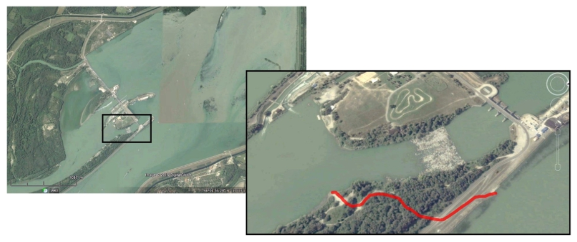
The Čunovo lock has to be portaged, and as the map in the DKV guide is a bit confusing at this point, I have included a google-earth screenshot with the approximately 200 m long portage route.
About ten kilometers after the transfer point there is an island – always seen in the direction of flow – on the right is another barrage, and in the left arm are the rapids of Dunakiliti. It is not possible to navigate them, but they can be bypassed on the left bank.
In Đerdap I and II, the rapids can only be passed downstream on the left bank, the Romanian bank.
Is it possible to swim in the Danube?
The water quality of the Danube – despite the river being the largest polluter of the Black Sea – is generally satisfactory to good in most places. In addition, the discharge of wastewater is generally decreasing with the construction of additional wastewater treatment plants. The self-purification capacity of the river is also enormous, and a few kilometers after even very massive discharges, the water is already relatively clean again. Bathers can often be seen – if the bank conditions allow it – and it is quite possible to swim in the Danube and cool off.
What border controls are to be expected?
As the river with the most riparian states in the world, the Danube is also to a large extent a border river.
From Germany to the Hungarian-Croatian-Serbian border there are no more controls, all countries belong to the Schengen area and crossing the border is as easy as crossing from Baden-Württemberg to Bavaria.
In Mohács you have to report your departure from Hungary for the first time. The police station is located on the right bank of the river right next to the landing stage.
A few kilometers later, you have to report your entry into Serbia on the left bank in Bezdan/Бездан. There is a ship there with the inscription “LUKA Bezdan/ЛУКА Бездан”, the border control station. Alternatively, you can decide to enter Croatia first, then report to the Croatian authorities in the first town, but from now on stay on the right bank and enter Serbia later.
You then leave Serbia in Prahovo/Прахово and enter Bulgaria in Vidin/Видин. Mooring from the Serbian-Bulgarian border to Novo Selo/Ново Село, the first Bulgarian town, is not permitted, but is occasionally tolerated.
Later, you leave Bulgaria at Silistra/Силистра and enter Romania on the right bank a few kilometers after the border.
It is not possible to enter Moldova, as the Moldovan bank is only a few hundred meters wide and a port is being built at this point. Here you should keep to the right bank, the Romanian bank.
It may be possible to enter Ukraine, but you should be prepared for long waiting times of several hours in Reni/Рени. You must have a Ukrainian entry stamp in your passport to drive through the Kilija arm. Without a stamp, you will be forced to paddle back under the supervision of a police boat, and the checks are as frequent as they are thorough.
Failure to report entry can be quite expensive, especially in Serbia, as the country is not a member of the EU, and the regulations should therefore be carefully observed. However, the daily obligation to register with the police, which is mentioned in a number of travel guides as being mandatory in Serbia, is no longer applicable. Wild camping and staying in the country is no problem at all if you have the Serbian entry stamp in your passport or if your entry was registered with your identity card.
As a general rule, mooring is only permitted on the bank of the country in which you have officially entered. If you have registered in Serbia, you are not allowed to go to the Croatian or Romanian bank for a short time, so you should always stay on the Serbian side of the river. The same applies to the Romanian-Bulgarian border. If you decide to drive to the other side, you should do so in a town with a border control station where you can officially enter the country. However, you must then remain on this side and are not allowed to return briefly, but must report to the authorities again. The EU does not necessarily mean the Schengen area, and crossing the border illegally – even if it is a green border – can have quite unpleasant consequences: a report, fines and hours of waiting at a police station.
However, these things can change and it is always a good idea to check the travel information provided by the German Foreign Office before you travel.
I would strongly advise against corruption or any attempts at corruption. This should be a matter of course, but unfortunately there are still rumors about the supposedly corrupt South-East Europe. However, the key words – here as everywhere else – are friendliness and respect, acceptance of the rules and laws and, in some cases, just a little patience. In any case, a smooth journey without complications and hassle is easily possible.
Driving license and vehicle documents
There is no obligation to mark kayaks or canoes. The flag requirement, which is occasionally mentioned, is also not a regulation. If you still want to do it: the flag of the country in which the boat has its home port is at the stern and the flag of the country in which you are currently located is at the bow.
Muscle-powered small craft are generally treated in the same way as a bicycle by the authorities; you don’t need a boating license, nor does the boat have to have a license plate or a name. However, just as cyclists need to know the traffic signs and the German Road Traffic Regulations (StVO), anyone who is out on the water should also know the Inland Waterways Regulations (Binnenschifffahrtsstraßen-Ordnung).
It also makes sense to write your name, address and telephone number on the inside with a waterproof pen. If it should get lost or drift away, this will definitely make it easier to find again.
And what about the mosquitoes?
This varies from year to year and also from region to region.
In general, there are always mosquitoes near bodies of water. There are more during high water and floods, fewer in dry years, and you are never completely spared from them.
The big advantage of paddling is that mosquitoes never stay on the water or in direct sunlight. During the day, you are a few meters away from the shore in your boat and safe even during the worst swarms. This changes on land. Mosquitoes like to sit in the shady undergrowth, and it can get very unpleasant at dawn and dusk. A fire only helps to a limited extent, and even then only if you sit right in the smoke, so that’s not the solution either. The situation is usually better in cities, on a slightly windy hill or if you can pitch your tent on a short lawn, which is unfortunately not always possible. The consolation is that when it gets completely dark, the mosquitoes go to sleep too.
It is therefore definitely advisable to bring mosquito repellent with you, preferably two or three bottles, as the usual Autan is not available everywhere, and the effectiveness of the various products available downstream varies greatly.
Do you have a question or are you missing important information?
If, in your opinion, important topics or questions are not covered here or if you would like to contribute information and tips, please write to me and I will answer your questions – if I can – or add your comments here.